


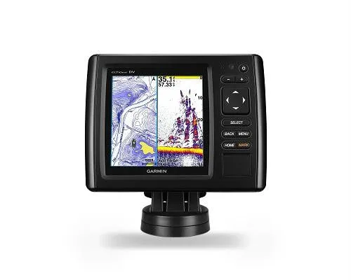
Garmin echoMAP 52cv 5"" CHIRP Fishfinder Chart plotter
Model: 010-01566-00UPC: 753759147587753759147570
- 5-inch color display with keypad control
- Preloaded worldwide basemap for general reference
- Includes Quickdraw Contours custom HD map creation software
- Internal 5 Hz GPS updates position and heading 5 times per second
It’s time you started fishing with the power of CHIRP sonar. The easy-to-install, easy-to-use 5-inch echoMAP CHIRP 52cv chartplotter includes transducer for high wide CHIRP sonar and Garmin CHIRP ClearVü™ for clear scanning sonar images. It includes Quickdraw Contours software to instantly create your very own HD maps with 1-foot contours as you fish. Internal 5 Hz GPS updates position and heading 5 times per second. Cords plug directly into the mount, allowing you to quickly install and remove your device from power and mount. Transom and trolling motor mounts included.
The built-in sonar capabilities of echoMAP CHIRP 52cv include CHIRP sonar, the most sophisticated sonar technology available for the fishing and boating public. CHIRP sonar provides amazingly clear target separation and definition because it puts even more energy onto the target than traditional sonar. It also includes sonar-recording capability that coordinates the timing of the sonar return with your boat's position and saves digital information for playback on a computer using HomePort™ planning software. Use the user data sharing cable to share waypoints and routes between multiple devices.
Garmin ClearVü scanning sonar gives you a nearly photographic, wide image of what passes below your boat. You clearly see structure, submerged objects and fish. Traditional Garmin HD-ID™ sonar and ClearVü scanning sonar are combined into 1 transducer. Also provides HD-ID support for Minn Kota® and MotorGuide® trolling motors with integrated transducers.
Instantly create personalized HD fishing maps onscreen with 1-foot contours. Tailor them to fit your needs. These are your maps — you own them. Keep the data to yourself, or share it with the Quickdraw Community on Garmin Connect™.
Fast, responsive 5 Hz GPS and GLONASS refreshes your position and heading 5 times each second to make your movement on the screen more fluid. Now it’s quick and easy to drop up to 5,000 accurate waypoints and find your way back to your secret fishing hot spots.
When you’re off the water, it’s easy to keep your echoMAP CHIRP safe and secure. You don’t have to mess with plugging and unplugging wires from the unit because the cords plug directly into the mount. This allows you to quickly install and remove your echoMAP CHIRP from power and the mount.
A single microSD™ card slot provides expandable memory for accessory map purchases, such as LakeVü HD, LakeVü HD Ultra with Max Def Lakes, BlueChart® g2 HD or BlueChart® g2 Vision® HD, which adds Garmin patented Auto Guidance and other great features.
If you have waypoints, tracks or frequently used routes stored on another manufacturer’s GPS product — or on a Garmin handheld device — it’s easy to transfer those items to your new Garmin chartplotter via industry-standard GPX software formatting.
With enhanced Version 2.0, you have access to more features and capabilities. You’re able to adjust the calculated Auto Guidance pathway by inserting "via" points at interim stops or landmarks along your desired route. You can easily review hazard points along your calculated path. And you can even engage your compatible Garmin autopilot to follow the Auto Guidance route, automatically. Other 2.0 enhancements give you the ability to calculate arrival times at any point on your route (great for timing arrivals to correspond with bridge openings and other time-critical events). Better still, you can now save your plotted Auto Guidance paths for future navigation by backing them up on an SD™ card with your BlueChart g2 Vision or LakeVü HD Ultra cartography .
Auto Guidance is for planning purposes only and does not replace safe navigation operations.
Specifications| Display size | 3.54"" x 3.54""; 5.0"" diagonal |
| Display resolution | 480 X 480 |
| Display type | WQVGA display |
| Water rating | IPX7 |
| Antenna | Internal only |
| NMEA0183 Compatible | Yes |
| Garmin Marine Network ports | None |
| Maps & Memory | |
| Preloaded maps | None |
| Accepts data cards | 1 microSD™ card |
| Waypoints | 5,000 |
| Routes | 100 |
| Track log | 50,000 points; 50 saved tracks |
| Chartplotter Features | |
| Garmin Sonar compatible | Yes |
| Supports AIS (tracks target ships position) | Yes |
| Supports DSC (displays position data from DSC-capable VHF radio) | Yes |
| Tide tables | Yes |
| BlueChart® Mobile (planning) compatible | No |
| Sonar Features and Specifications | |
| Dual-frequency (50/200 kHz) sonar capable | Yes |
| Dual-beam (77/200 kHz) sonar capable | Yes |
| Transmit power | 500 W (RMS) / 4,000 W (peak to peak) |
| CHIRP sonar technology | Yes, built-in |
| ClearVü | Yes, built-in |
| SideVü™ | No |
| Maximum depth | 2,300 ft @ 77 kHz, freshwater 1,100 ft @ 77 kHz, saltwater (depth capacity is dependent on water bottom type and other water conditions) |
| Bottom lock (shows return from the bottom up) | Yes |
| Water temperature log and graph | Yes |
| Sonar recording | Yes |
| Sonar history rewind | Yes |
| Connections | |
| NMEA 0183 input ports | 1 |
| NMEA 0183 output ports | 1 |
| Video input ports | None |
| Video output ports | None |
| Wireless connectivity | No |
| Dimensions | 6.8"" x 5.4"" x 1.7"" (17.3 x 13.6 x 4.4 cm) |
What's in the Box:
- echoMAP CHIRP 52cv with worldwide basemap
- Power/data cable
- Tilt/swivel mount
- Flush mount
- Documentation
- Protective Cover
- Hardware
 Set of 4")


